Esta entrada fue actualizada el 6 de febrero del 2016.
(This post was updated February 6th, 2016.)
Turrialba Volcano National Park
Santa Cruz of Turrialba, Cartago

El impresionante Volcán Turrialba
(The impressive Turrialba Volcano)
Turrialba Volcano was named after the region of Costa Rica in which the volcano is situated in Turrialba County, Cartago of Costa Rica. There is no clear consensus on the origin of the name Turrialba, but historians disagree with attempts to attribute the name to the patronym Torrealba (from Aragon in Spain) or from the Latin Turris alba (white tower). The general consensus is that Turrialba derives from a local Indian language (Huetar) but there is no agreement on its actual roots.
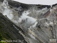
The stratovolcano is 3,340 m (10,958 ft) high and is about 45 minutes from the Atlantic slope town of Turrialba. The summit has three craters, one of which has fumaroles and sulfur pits. Visitors used to be able to hike down into the main crater, but increased gaseous activity has caused the time at the summit to be limited to no more than fifteen minutes. The hike to the top from where the vans usually are forced to stop takes about one to three hours depending on the ability of the hikers. Below the summit is a mountain range and cloud forest, with ferns, bromeliads, lichens and mosses. During the 19th century, it explosively erupted several times (1847?, 1853, 1855, 1861?, 1864–1865, 1866), producing pyroclastic flows. The last major eruption was in 1866, but in January 2001, the volcano reported increased activity, displaying strong fumaroles at the central craters. The volcanic activities have increased since 2005. In January 2010, the volcano emitted ash, and two villages, La Central and El Retiro, were evacuated.
Turrialba is adjacent to Irazú and both are among Costa Rica's largest volcanoes. It had at least five large explosive eruptions in last 3500 years.
A viewing platform (Mirador) and path and steps were built overlooking the crater by volunteers from the charity Raleigh International in 2007. On clear days both the Pacific Ocean and Caribbean Sea can be seen. (Source: Turrialba Volcano, available on September 26th, 2010)
We had the opportunity to visit the Volcano in 2005, 2006 and 2008. In 2005 we had to walk to the crater. On the other two visits the road was in good condition, so we reached the volcano by car. Early this year we tried to go the volcano, but the road was in pretty bad shape, even to 4x4 vehicules and the access was restricted due to the eruptions.
In mid 2010 we reached La Central, 7 kms (4.4 miles) from the crater. From there on there is no public access, due to the bad road condition. These are the last photographs posted in the blog.
The National University of Costa Rica (Universidad Nacional) has installed a live web cam, 600 meters east (1,970 feet) from the west crater (Live Turrialba Volcano Camera, available on September 26th, 2010).
Click on the images to enlarge.
-----------------------------------
El volcán Turrialba es un cono volcánico de Costa Rica ubicado en el cantón de Turrialba, en la provincia de Cartago, en la Cordillera Central, dando nombre al Parque Nacional que le envuelve, el Parque Nacional Volcán de Turrialba. Con su cumbre situada a 3340 m de altitud es el segundo volcán más alto de Costa Rica, superado solo por el Volcán Irazú (3432 m). Su nombre es de origen indígena y deriva del de dos pueblos que existían en 1569, llamados Turrialba la grande y Turrialba la chica. (Fuente: Volcán Turrialba, disponible el 26 de setiembre del 2010).
Tuvimos la oportunidad de visitar el Volcán en el 2005, 2006 y 2008. La primera vez tuvimos que caminar hasta el cráter. En las otras ocasiones el camino estaba en buenas condiciones y llegamos en carro. A principios de año tratamos de llegar al volcán, pero el camino está intransitable y el acceso restringido debido a las erupciones.
A mediados del 2010 tuvimos la oportunidad de llegar hasta La Central, a 7 kms del cráter. De ahí en adelante, el acceso está restringido para el público y el camino está en malas condiciones. Estas son las últimas fotografías que están en el blog.
La Universidad Nacional instaló una cámara, 600 metros al este (1,970 pies) del cráter oeste (Cámara en vivo Volcán Turrialba, disponible el 26 de setiembre del 2010).
Haga click sobre las imágenes para agrandarlas.
-----------------------------------
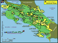
Este es un mapa de la zona. La siguiente dirección electrónica tiene un mapa detallado de Costa Rica (Mapa detallado Costa Rica, disponible el 13 de agosto del 2010).
(This is a map of the area. The link will take you to a detailed map of Costa Rica.)

Haga click en el siguiente link para observar un mapa ampliado de los volcanes de Costa Rica: OVSICORI Universidad Nacional, disponible el 12 de setiembre del 2011.
(Click on the following link to observed an extended map of the volcanoes of Costa Rica: OVSICORI Universidad Nacional, available on September 12th, 2011.)


Mapa turístico de Costa Rica
(Touristic map of Costa Rica)


Otra vivienda de 100 años. Pertenece al señor Federico Montero.
(Another 100 year old house. It belongs to Mr. Federico Montero.)

Fotografía tomada desde el Volcán Turrialba Lodge
(Photograph taken from the Volcán Turrialba Lodge)


Cráter central
(Central crater)


Cráter este
(East crater)


Cráter oeste (este es el activo)
(Active west crater)


Vistas desde el Cerro Porfía
(Views from Cerro Porfía)


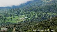
Vista de La Central y el Volcán Turrialba Lodge
(View of La Central and Volcán Turrialba Lodge)
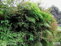
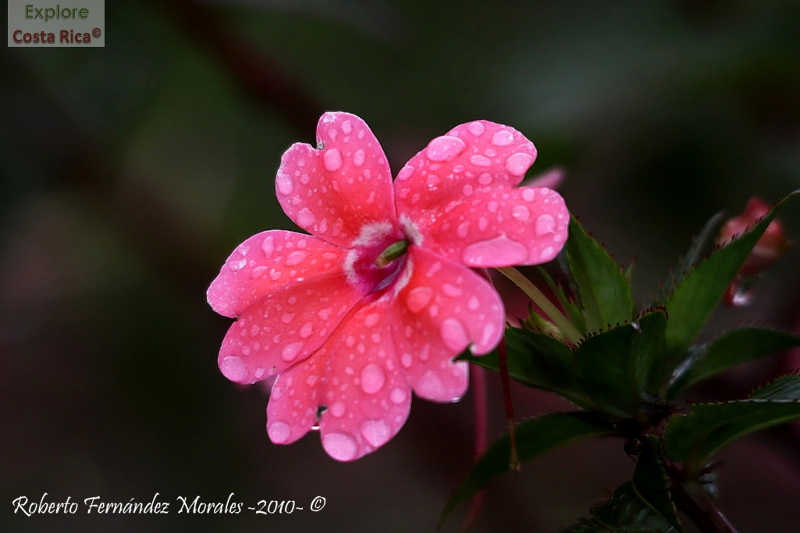
Vegetación y flores de la zona entre La Pastora y La Central
(Vegetacion and flowers between La Pastora and La Central)


Antigua edificación en La Central, en la base del camino hacia el Volcán
(Old building in La Central, just in the base of the road that leads to the volcano)


Fotografías tomadas en el 2010
(Photographs taken in 2010)
Volcán Turrialba
(Turrialba Volcano)


Se observa la vegetación quemada cerca del cono volcánico
(You can see the damage in the vegetation near the volcanic cone)


Fotografías tomadas desde el Volcán Turrialba Lodge
(Photographs taken from the Volcán Turrialba Lodge)


(Access road)
 Iglesia
(Local Church)
 Escuela
(Local school)

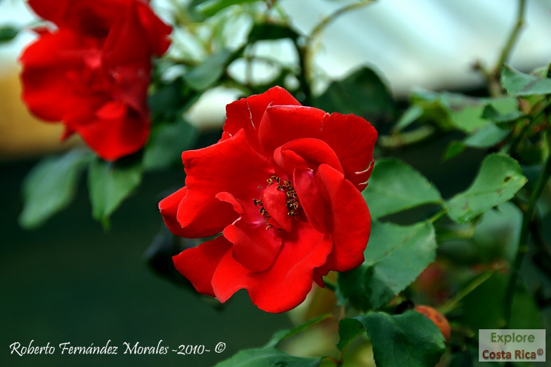
Flores y vegetación de la zona
(Flowers and vegetation in the zone)


Vista del Cerro de La Muerte desde la carretera entre La Pastora y La Central
(View of the Cerro de La Muerte from the road between La Pastora and La Central)

Aves
(Birds)
Bienteveo grande (pecho amarillo) -Great Kiskadee-
(Pitangus sulphuratus)
+-Great+Kiskadee-+(p+210)+IMG_6702+A1.jpg)
+-Great+Kiskadee-+(p+210)+IMG_6703+A1.jpg)
+-Great+Kiskadee-+(p+210)+IMG_6706+A1.jpg) Brillante frentiverde -Green crowned Brilliant-
Brillante frentiverde -Green crowned Brilliant-
(Heliodoxa jacula)
 Chingolo (Comemaíz) –Rufous collared Sparrow-
+%E2%80%93Rufous+collared+Sparrow-+(p+306)+IMG_7040+A1.jpg) Chispita gorginaranja (Chispita o Colibri mosca) -Scintillant Hummingbird-
Chispita gorginaranja (Chispita o Colibri mosca) -Scintillant Hummingbird-
(Selasphorus scintilla)
+-Scintillant+Hummingbird-+(p+138)+IMG_6756+A1.jpg)
+-Scintillant+Hummingbird-+(p+138)+IMG_6758+A1.jpg)
+-Scintillant+Hummingbird-+(p+138)+IMG_6762+A1.jpg) Colibrí montañes gorgimorado -Purple throated Mountain gem-
Colibrí montañes gorgimorado -Purple throated Mountain gem-
+IMG_6780+A1.jpg)
+IMG_7042+A1.jpg)
+IMG_7068+A1.jpg) Gavilán colirrojo (Gavilán valdivia) -Red Tailed Hawk-
Gavilán colirrojo (Gavilán valdivia) -Red Tailed Hawk-
(Buteo jamaicensis)

+-Red+Tailed+Hawk-+(p+46)+IMG_7013+A1.jpg)
+-Red+Tailed+Hawk-+(p+46)+IMG_7014+A1.jpg) Mirlo negruzco (Escarchado o Escarchero) -Sooty Robin-
Mirlo negruzco (Escarchado o Escarchero) -Sooty Robin-
+-Sooty+Robin-+(p+248)+IMG_6903+A1.jpg)
+-Sooty+Robin-+(p+248)+IMG_6953+A1.jpg) Quetzal -Resplandent Quetzal-
Quetzal -Resplandent Quetzal-
(Pharomachrus mocinno)


+IMG_6805+A1.jpg)
+IMG_6806+A1.jpg)
+-Yellow+faced+Grassquit-+(p+296)+IMG_6746+A1.jpg)
+IMG_6826+A1.jpg)
+IMG_6827+A1.jpg)
(This is a map of the area. The link will take you to a detailed map of Costa Rica.)

Mapa de los volcanes de Costa Rica
(Map of the volcanoes of Costa Rica)
(Click on the following link to observed an extended map of the volcanoes of Costa Rica: OVSICORI Universidad Nacional, available on September 12th, 2011.)

El siguiente enlace permite conocer las condiciones meteorológicas de la zona: Estación Volcán Turrialba.
(The following link allows to know the weather in the area: Estación Volcán Turrialba.)
Mapa turístico de la provincia de Cartago
(Touristic map of the Cartago province)

Mapa turístico de Costa Rica


Cristo en el cruce hacia el Volcán Irazú
(Statue of Christ in the road intersection towards the Irazú Volcano)

Mapa de Pacayas
(Pacayas map)

Casas viejas en Pacayas
(Old houses in Pacayas)
Esta vivienda tiene más de 100 años. Perteneció al señor Beto Cruz y a la señora Carmela Jiménez. Las últimas habitantes de la vivienda fueron las Hermanas Salesianas de la Orden de María Auxiliadora.
(This house is over 100 years old. It belonged to Mr. Beto Cruz and Mrs. Carmela Jiménez). The last residents were nuns.)
(This house is over 100 years old. It belonged to Mr. Beto Cruz and Mrs. Carmela Jiménez). The last residents were nuns.)


Antigua lechería de la finca a la cual pertenecía la vivienda cuyas fotografías se muestran anteriormente. La cubierta de techo es la que se instaló originalmente, es decir, tiene más de 100 años.
(Old dairy of the farm to which the house shown in previous photographs belongs. The building has the original roofing, that is, it is over 100 years old.)
(Old dairy of the farm to which the house shown in previous photographs belongs. The building has the original roofing, that is, it is over 100 years old.)

(Another 100 year old house. It belongs to Mr. Federico Montero.)

Fotografías tomadas en los años 2005, 2006 y 2008
(Photographs taken in 2005, 2006 and 2008)
Fotografía tomada desde el Volcán Turrialba Lodge
(Photograph taken from the Volcán Turrialba Lodge)

El Volcán en el camino de ascenso
(Photograph of the volcano from the access road)

Vista general de los tres cráteres
(General view of the three craters)
(Photograph of the volcano from the access road)

Vista general de los tres cráteres
(General view of the three craters)


(Central crater)


Cráter este
(East crater)


(Active west crater)


Vistas desde el Cerro Porfía
(Views from Cerro Porfía)


(View of La Central and Volcán Turrialba Lodge)

Este documento de 1921 describe un ascenso al Volcán Turrialba. Incluye fotografías del cráter. El documento puede ser descargado.
(This 1921 document describes an ascent to the Turrialba Volcano. It includes photographs of the crater. The document can be downloaded.)
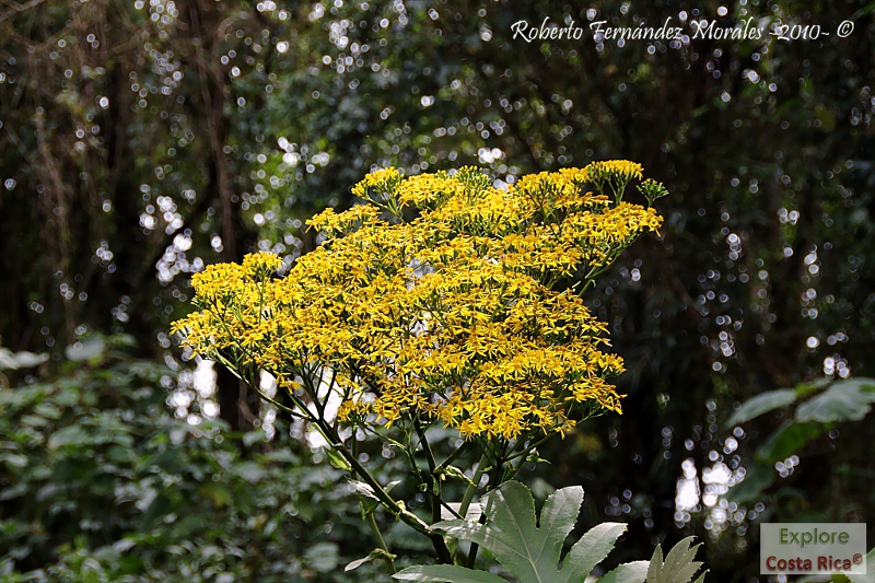
Vegetación y flores de la zona entre La Pastora y La Central
(Vegetacion and flowers between La Pastora and La Central)


(Old building in La Central, just in the base of the road that leads to the volcano)


(Photographs taken in 2010)
Volcán Turrialba
(Turrialba Volcano)


Bueno, aquí alguien se equivocó con la traducción. No es lo mismo SCHEDULE que SCHELUDE (esto todavía no conozco lo que significa). Lo importante es que los turistas entiendan que el Parque está abierto de 8:00 a.m. a 3:30 p.m.
(There is an error in the spelling of SCHEDULE on the sign.)
(There is an error in the spelling of SCHEDULE on the sign.)

(You can see the damage in the vegetation near the volcanic cone)


(Photographs taken from the Volcán Turrialba Lodge)


La Central es un pequeño caserío que se ubica a 7 kms del cráter. Al llegar al final del caserío, el camino a la derecha va hacia el volcán y el de la izquierda llega al Volcán Turrialba Lodge.
(La Central is a group of houses located 7 kilometers from the crater. At the end of the road, if you make a right turn, you will reach the volcano and the lef turn takes you to the Volcán Turrialba Lodge.)
Calle de acceso(La Central is a group of houses located 7 kilometers from the crater. At the end of the road, if you make a right turn, you will reach the volcano and the lef turn takes you to the Volcán Turrialba Lodge.)
(Access road)

(Local Church)

(Local school)

(Flowers and vegetation in the zone)


Fotografías tomadas por OVSICORI-UNA, de la erupción del 18 de enero del 2012, disponible el 18 de enero del 2012.
(Photographs taken by OVSICORI-UNA, of the eruption of January 18th, 2012, available on January 18th, 2012.)


Vista del Cerro de La Muerte desde la carretera entre La Pastora y La Central
(View of the Cerro de La Muerte from the road between La Pastora and La Central)

Aves
(Birds)
Bienteveo grande (pecho amarillo) -Great Kiskadee-
(Pitangus sulphuratus)


(Heliodoxa jacula)

(Zonotrichia capensis)

(Selasphorus scintilla)
Gracias al señor Álvaro Herrera Villalobos del INBIO por ayudarme a identificar esta ave.
(Our gratitude to Mr. Álvaro Herrera of the INBIO for helping me to identify the bird.)
(Our gratitude to Mr. Álvaro Herrera of the INBIO for helping me to identify the bird.)


(Lampornis calolaemus)


(Buteo jamaicensis)
Gracias al señor Álvaro Herrera Villalobos del INBIO por ayudarme a identificar esta ave.
(Our gratitude to Mr. Álvaro Herrera of the INBIO for helping me to identify the bird.)


(Turdus nigrescens)


(Pharomachrus mocinno)


Reinita garganta de fuego -Flame throated Warbler-
(Parula gutturalis)
Gracias al señor Álvaro Herrera Villalobos del INBIO por ayudarme a identificar esta ave.
(Our gratitude to Mr. Álvaro Herrera of the INBIO for helping me to identify the bird.)


Semillerito cariamarillo (Gallito) -Yellow faced Grassquit-
(Tiurus olivaceus)

Tangara de monte ojeruda - Common bush Tanager-
(Chlorospingus ophtalmicus)


Tangara vientricastaña -Spangle cheeked Tanager-
(Our gratitude to Mr. Álvaro Herrera of the INBIO for helping me to identify the bird.)
 Tirano tropical (Pecho amarillo) -Tropical Kingbird-
+-Tropical+Kingbird-+(p+212)+IMG_6784+A1.jpg) Zorzal piquinegro (Cuitiento) -Black billed Nightingale Thrush-
Zorzal piquinegro (Cuitiento) -Black billed Nightingale Thrush-
+-Black+billed+Nightingale+Thrush-+(p+246)+IMG_6975+A1.jpg)
+-Black+billed+Nightingale+Thrush-+(p+246)+IMG_6976+A1.jpg)
+-Black+billed+Nightingale+Thrush-+(p+246)+IMG_6988+A1.jpg)
En La Pastora, fotografiamos a estos valientes haciendo parapento
(In La Pastora, we photographed these brave people practicing paragliding)


(Tangara dowii)
Gracias al señor Álvaro Herrera Villalobos del INBIO por ayudarme a identificar esta ave.(Our gratitude to Mr. Álvaro Herrera of the INBIO for helping me to identify the bird.)

(Tyrannus melancholicus)

(Catharus gracilirostris)


En La Pastora, fotografiamos a estos valientes haciendo parapento
(In La Pastora, we photographed these brave people practicing paragliding)


Al regresar a San José nos encontramos con este ciudadano que se preocupa, quiere y ama la flora y la fauna de nuestro país. Vean las calcamonías que llevan su carro:
1. Prohibido cazar.
1. Prohibido cazar.
2. No al aleteo.
3. O sembramos árboles o nos lleva puta!!
4. Si a la vida...No minería
Gracias a Dios vivimos en Costa Rica!!!
(On our way back home we found this concerned citizen who loves and cares the flora and wildlife of our country. The stickers of his vehicle say:
1. No hunting.
2. No shark finning.
3. Either we plant trees or we are f.....!!
4. Yes to life. No mining.
Thank God we live in Costa Rica!!!)
(On our way back home we found this concerned citizen who loves and cares the flora and wildlife of our country. The stickers of his vehicle say:
1. No hunting.
2. No shark finning.
3. Either we plant trees or we are f.....!!
4. Yes to life. No mining.
Thank God we live in Costa Rica!!!)

Migración de aves
(Bird migration)
Las siguientes entradas de este blog están relacionadas con la actual:
(The following posts of this blog are related to the actual one):
- La Fortuna de San Carlos (Volcán Arenal)
Más fotografías de Explore Costa Rica en Flickr -Roberto Fernández-Morales-.
(More photographs of Explore Costa Rica on Flickr -Roberto Fernández-Morales-.)
Conozca y cuide a Costa Rica. Es de todos nosotros!!
Conozca y cuide a Costa Rica. Es de todos nosotros!!
(Get to know and take care of Costa Rica. It belongs to all of us!!)


6 comentarios:
Saludos my friend:
Muy bonitas fotos, sigue adelante con tu nuevo entrenimiento, así nos da la oportunidad de conocer un poco más el país a los que andamos con poco tiempo.
Brother. Qué fotos. Gracias por comaprtirlas con nosotros. A pesar de que vos sos "el pata caliente" la verdad es que así nos permitís gozarnos del país donde el Señor nuestro Dios Jesús nos ha puesto a vivir y el privilegio que nos ha dado. Realmente es de apreciar el esfuerzo, el trabajo y la dedicación tuya y de Katia. Sigan paseando y dándonos la oportunidad a nosotros de conocer este bellísimo país.
Saludos y abrazos,
José Luis Salas.--
Estimado Roberto:
Gracias por tu comentario.
Voy a aprovechar ahora que vas a estar trabajando fuera de San José para acompañarte y fotografiar mientras vos cumplís con tus obligaciones. Bueno...al menos a mi me parece una buena idea.
Saludos.
Mi estimado José Luis:
Gracias por tu comentario y por el correo electrónico que me enviaste.
Definitivamente Dios nos ha premiado con un país tan bello y con gente muy especial.
Espero que Kattia y yo tengamos la oportunidad de conocerlo en detalle.
Pronto voy a subir la foto del martín pescador que te prometí.
Me alegra que estes recuperado y acordate que no es lo mismo GEL DE ORTIGA que MAL DE ORTEGA. Tené cuidado.
Un abrazo.
Bellisimo blog. Las fotografias estan impresionantes. Mil felicidades y motivarlos a que continuen con este maravilloso trabajo para dar a conocer que somos un pais privilegiado. Besitos!
Querida Libia:
Muchas gracias por el comentario.
Definitivamente nuestro país ha sido bendecido por Dios y por eso es tan bello.
Un beso.
Publicar un comentario