Esta entrada fue actualizada el 18 de marzo del 2016.
(This post was updated March 18th, 2016.)
Playa Tivives
(Tivives Beach)
(Tivives Beach)
Costa Rica has 227,413 sq miles of territorial sea, with a coast length of 131 miles in the Caribbean Sea and 687 miles in the Pacific Ocean. The big continental platform is one of the factors that determine our rich sea life. Population on the coast represents 5% of the total of habitants.
In the last years, wetland protection has been a relevant national and international issue, due to the increasing threats to these ecosystems that benefit mankind. Wetlands are 7% of the total territory (864,860 acres) and currently there are more than 350 and include mangroves, coral reefs, estuaries, swamps, lakes and lagoons.
Mangroves are 1% of the total territory and are found mostly on the Pacific coast (see figures below). In 1989, mangrove areas were estimated in 101,317 acres and in 1993 in 74,131 acres, which represents a 27% reduction. Actually there are approximately 98,841 acres of mangroves. (Source: INBIO, available on August 18th, 2010).
The photographs were taken at Bajamar Beach and Tivives Beach, near Puntarenas.
To take some of the photographs I had to walk approximately 330 yards into the mangrove, with the water up to my waist. There are crocodiles in the mangrove, so you have to be very careful. The experience is thrilling, since I had never seen so many birds together. Probably there were 1,000 or more and you could see nests, eggs, nestlings, hatchlings and chicks.
-----------------------------------
Special gratitude to Mr. Oscar Ramírez Alán of the Ornithological Association of Costa Rica and Mr. Álvaro Herrera Villalobos of the INBIO for helping to identify some of the birds.
-----------------------------------
Click on the images to enlarge.
Special gratitude to Mr. Oscar Ramírez Alán of the Ornithological Association of Costa Rica and Mr. Álvaro Herrera Villalobos of the INBIO for helping to identify some of the birds.
-----------------------------------
Click on the images to enlarge.
-----------------------------------
Costa Rica cuenta con 589.000 km2 de mar territorial, con una longitud de costa de 210 km en el Caribe y 1.106 km en el Pacífico. La amplia plataforma continental de la costa Pacífica es uno de los factores determinantes de su riqueza pesquera. La población de la línea costera representa el 5% del total de habitantes del país.
En los últimos años, la protección de los humedales ha cobrado relevancia nacional e internacional, debido principalmente a las crecientes amenazas contra estos ecosistemas, que son de gran beneficio para las personas. Los humedales abarcan cerca del 7% del territorio nacional (350,000 ha) y suman más de 350 e incluyen manglares, arrecifes coralinos, esteros, pantanos, lagos y lagunas.
Los manglares ocupan aproximadamente el 1% del territorio costarricense y se encuentran a lo largo de la costa Pacífica, principalmente en el Golfo de Nicoya (ver figuras abajo). En 1989 el área de manglar se estimaba en 41,002 ha y en 1993 en 30,000 ha, lo cual significa una reducción del 27% en cuatro años. Actualmente la extensión es de aproximadamente 40,000 ha. (Fuente: INBIO, disponible el 18 de agosto del 2010).
Las fotografías fueron tomadas en Playa Bajamar y Playa Tivives, cerca de Puntarenas.
Para tomar algunas de las fotografías tuve que caminar unos 300 metros dentro del manglar, con el agua a la cintura. En el manglar hay lagartos, así que hay que tener cuidado. La experiencia es impresionante, ya que nunca había visto tantas aves juntas. Probablemente había unas 1,000 o más y se podían observar los nidos, huevos y pichones de todos los tamaños.
-----------------------------------
Un agradecimiento muy especial al señor Oscar Ramírez Alán de la Asociación Ornitológica de Costa Rica y al señor Álvaro Herrera Villalobos del INBIO por ayudarme a identificar algunas de las aves.
-----------------------------------
Haga click sobre las imágenes para agrandarlas.
-----------------------------------
Este es un mapa de como llegar a Playa Bajamar y Playa Tivives. La siguiente dirección electrónica tiene un mapa detallado de Costa Rica (Mapa detallado Costa Rica, disponible el 13 de agosto del 2010).
(This is a map of how to get to Playa Bajamar and Playa Tivives. The link will take you to a detailed map of Costa Rica.)
Playas bandera azul
(Blue flag beaches)
xcvbnmSeguidamente se muestra la tabla de distancias entre San José y Playa Bajamar.
(The following table shows the distances between San Jose and Bajamar Beach.)
(This is a map of how to get to Playa Bajamar and Playa Tivives. The link will take you to a detailed map of Costa Rica.)
Mapa turístico de Costa Rica
(Costa Rica´s touristic map)
Playas bandera azul
(Blue flag beaches)
(The following table shows the distances between San Jose and Bajamar Beach.)
Mapas de humedales, manglares y arrecifes en Costa Rica
(Wetlands, mangroves and coral reefs maps in Costa Rica)
(Wetlands, mangroves and coral reefs maps in Costa Rica)
Mirador de Playa Bajamar
(Bajamar Beach viewpoint)
En Bajamar, a inicios de agosto se celebra la Romería en honor a la Vírgen de Los Ángeles. Esta tradición tiene varios años y las personas caminan hasta una vivienda al extremo de la playa en donde se celebra misa. La siguiente entrada tiene mayor información sobre el tema: Romería 2010.
(In Bajamar, on the first days of August, a pilgrimage is celebrated in honor of the Virgin of Los Angeles. This tradition is several years old and people walk to a home at the end of the beach where Mass is celebrated. The following post has more information on the subject: Romería 2010.)
Playa Tivives
(Tivives Beach)
Desembocadura del Río Jesús María al mar, en Playa Tivives. Los lagartos pasan del río al mar y viceversa, razón por la cual es peligroso bañarse en la zona. En la fotografía se nota la diferencia en la coloración del agua.
(Jesús María River mouth in Tivives Beach. Alligators go from the river to the sea and vice versa. Swimming is pretty dangerous in this area. You can appreciate the difference in the water color were the river reaches the sea).
Manglar de Playa Bajamar
(Bajamar Beach mangrove)
Manglar blanco o manglar mariquita
(White mangrove or mariquita mangrove)
Algunas flores en la zona
(Some flowers in the area)
Aves
(Birds)
Cabezón plomizo -Rose throated Becard-
(Pachyramphus aglaiae)
Hembra
(Female)
Macho (Male)
Carpintero de Hoffman –Hoffman’s Woodpecker-
(Melanerpes hoffmannii)
Cigüeñon (Garzón o Guairon) -Wood Stork-
(Mycteria americana)
Copetón crestipardo -Brown crested Flycatcher-
(Myiarchus tyrannulus)
Cormoran neotropical (Pato chancho o Pato de agua) -Neotropic Cormorant-
(Phalacrocorax brasilianus)
Garceta azul -Little blue Heron-
(Egretta caerulea)
Garceta grande (Garza real) –Great Egret-
(Ardea alba)
Garceta nivosa –Snowy Egret-
(Egretta thula)
Garceta tricolor -Tricolored Heron-
(Egretta tricolor)
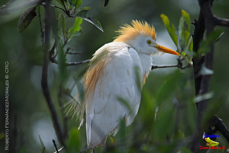
Garcilla bueyera (Garza del ganado) -Cattle Egret-
(Bubulcus ibis)
Garcilla verde –Green Heron-
(Butorides virescens)
Garrapatero piquiestriado (Tijo) -Groove-billed ani-
(Crotophaga sulirostris)
Garza tigre (Martín peña o Pájaro vaco) -Bare throted Tiger Heron-
(Tigrisoma mexicanum)
Gavilán cabecigris -Gray headed Kite-
(Leptodon cayanensis)
Gavilán cangrejero -Common black Hawk-
(Buteogallus anthracinus)
Gavilán chapulinero -Roadside Hawk-
(Buteo magnistrosis)
Golondrina lomiblanca -Mangrove Swallow-
(Tachycineta bicolor)
Ibis blanco (Coco) -White Ibis-
(Eudocimus albus)
Huevo
(Egg)
Ibis blanco (Coco) -White Ibis-
(Eudocimus albus)
Perico frentinaranja –Orange fronted Parakeet-
(Aratinga canicularis)
Reinita amarilla -Yellow Warbler-
(Dendroica virens)
Soterrey nuquirrufo (Chico Piojo o Salta piñuela) -Rufous naped Wren-
(Campylorhynchus rufinucha)
Tirano occidental -Western Kingbird-
(Tyrannus verticalis)
Titira coroninegra -Black crowned Tityra-
(Tityra inuisitor)
Tortolita colilarga (San Juan) -Inca Dove-
(Columbina inca)
Trogón cabecinegro (Viuda amarilla) -Black headed Trogon-
(Trogon melanocephalus)
Zopilote negro -Black Vulture-
(Coragyps atratus)
Migración de aves
(Bird migration)
Una amiga curiosa
(A curious friend)
Las siguientes entradas de este blog están relacionadas con la actual:
(The following posts of this blog are related to the actual one):
- Catarata Manantial Aguas Vivas
- Playa Agujas
- Playa Guacalillo
- Playa Tárcoles
- Puerto Caldera
- RNVS Hacienda Barú
- Playa Agujas
- Playa Guacalillo
- Playa Tárcoles
- Puerto Caldera
- RNVS Hacienda Barú
Más fotografías de Explore Costa Rica en Flickr -Roberto Fernández-Morales-.
Conozca y cuide a Costa Rica. Es de todos nosotros!!
(Get to know and take care of Costa Rica. It belongs to all of us!!)


